Google Is Using cinematic AI to Monitor Indian Farms
Google DeepMind is using satellite imagery and AI to map and monitor Indian farmland, bringing near-real-time agricultural intelligence to the field.
By singamankitha
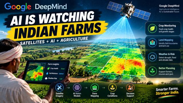
Google Is Using AI to Monitor Indian Farms
AI is moving far beyond chatbots.
In India, Google DeepMind is applying artificial intelligence to something much more physical: farmland.
Google DeepMind's AnthroKrishi team has developed satellite-based agricultural AI models designed to generate field-level insights across India's agricultural landscape.
The models can help map fields, identify crops and monitor agricultural events — turning satellite imagery into information that can potentially support better agricultural decisions.
And that could be a much bigger deal than another chatbot update.
From Satellites to Farm Intelligence
The basic idea is surprisingly simple.
Satellite imagery
↓
AI vision models
↓
Farm mapping
↓
Crop identification
↓
Monitoring
↓
Agricultural insights
Instead of looking at enormous amounts of satellite imagery manually, AI can process that information and turn it into structured agricultural data.
Google's work centers on two models:
Agricultural Landscape Understanding (ALU)
and
Agricultural Monitoring & Event Detection (AMED).
ALU focuses on understanding agricultural landscapes, including field boundaries and other landscape features such as water bodies and vegetation.
AMED builds on that foundation to monitor agricultural activity, including crop types and stages such as sowing and harvesting.
Why India Is an Important Test Case
India has an enormous and highly diverse agricultural landscape.
Different regions have different:
Crops
Weather patterns
Soil conditions
Irrigation systems
Farming practices
Seasonal cycles
That makes large-scale agricultural monitoring difficult.
Traditional field surveys can provide valuable information, but collecting detailed information across huge areas is time-consuming.
Satellite imagery provides a different approach.
A single observation can cover large areas.
AI can then help interpret that imagery at scale.
The result is the possibility of moving from:
“What is happening across this region?”
to:
“What is happening in this specific agricultural area?”
AI Can Turn Maps Into Decisions
Mapping farmland is only the beginning.
The real value comes when those maps become useful information.
Imagine an agricultural system that can identify:
Where are the fields?
What crops are being grown?
When were they planted?
Which areas are changing?
Where might crop conditions be different?
Which areas need closer attention?
This creates a pathway from raw satellite imagery to decision support.
Google says its agricultural AI models can provide field-level insights and support applications around agricultural resilience and productivity.
Near-Real-Time Agriculture
One of the most interesting parts of this technology is the frequency of monitoring.
According to reporting by The Indian Express, AMED uses historical data and is refreshed approximately every 15 days, while ALU's landscape mapping is refreshed less frequently.
That matters because agriculture changes continuously.
A field doesn't look the same throughout a growing season.
Planting happens.
Crops grow.
Weather changes.
Harvesting begins.
Extreme events can occur.
More frequent monitoring means agricultural intelligence can potentially become much more dynamic.
Instead of relying only on static maps, organizations can work with updated observations of agricultural conditions.
What Could Farmers and Businesses Do With This?
The technology could support many different agricultural applications.
Crop Monitoring
AI can help track where crops are growing and how agricultural areas are changing.
Land Mapping
Field boundaries and landscape features can be mapped at large scale.
Agricultural Planning
More detailed information can help organizations plan agricultural interventions.
Environmental Monitoring
Satellite-based systems can also provide information about vegetation, water bodies and landscape changes.
Drought Planning
Detailed landscape information can potentially support planning for water stress and drought-related events.
The important point is that AI isn't replacing farming knowledge.
It can provide another layer of information that farmers, researchers, businesses and governments can use alongside existing knowledge and observations.
This Is AI You Can't See
Most people experience AI through a screen.
They ask a chatbot a question.
They generate an image.
They write an email.
Agricultural AI is different.
You might never interact with the model directly.
Instead, AI works behind the scenes.
Satellite
→ captures imagery
AI
→ interprets the imagery
Agricultural system
→ turns the information into useful data
Human
→ makes the decision
That is an important model for how AI could transform physical industries.
The Bigger Opportunity Is Not Just Agriculture
The same architecture can work across many industries.
Think about the formula:
Sensors + AI + physical world + decision support
For agriculture, the sensor is often satellite imagery.
But similar approaches can be applied to:
Forestry
Water management
Climate monitoring
Disaster response
Infrastructure
Urban planning
Environmental observation
Supply-chain monitoring
AI becomes the intelligence layer sitting on top of huge amounts of real-world data.
India Is Becoming an Important AI Application Market
This story also highlights a broader development in India's AI ecosystem.
A lot of AI news focuses on models developed in the United States or China.
But some of the most interesting applications are about using AI to solve local problems.
Agriculture is one example.
Google says its India-first agricultural models were initially developed around India's landscape and are now expanding to other countries and platforms.
Google has also said Indian startups and institutions are using APIs from its agricultural AI models for applications related to agricultural resilience, crop productivity and farmer incomes.
That creates a different way to think about India's AI opportunity.
It isn't only about building the next frontier model.
It is also about building systems that understand India's:
Languages
Climate
Agriculture
Cities
Infrastructure
Businesses
Consumers
and
Local problems.
The AI + Satellite Combination Is Powerful
Satellite data has existed for decades.
AI has existed for decades.
What is changing is the ability to combine them at scale.
A satellite can collect enormous amounts of imagery.
AI can help process and classify that information.
Cloud infrastructure can distribute it.
APIs can make the resulting data accessible to other organizations.
That creates a complete technology pipeline:
Earth observation
→
AI interpretation
→
Structured data
→
API / visualization
→
Decision support
That is much more powerful than simply putting an AI chatbot on top of an existing application.
What This Could Mean for Indian Startups
This also creates opportunities for startups.
A company doesn't necessarily need to build its own satellite.
It can build applications on top of agricultural intelligence.
For example:
Satellite data
→ AI agricultural model
→ Startup application
→ Farmer / insurer / agribusiness / researcher
That could support products for:
Crop monitoring
Insurance
Agricultural finance
Supply chains
Farm advisory
Climate resilience
Resource planning
The model becomes infrastructure.
The startup builds the application.
But AI Is Not a Magic Farming Solution
There are important limitations.
Satellite observations still need to be interpreted carefully.
Ground-level conditions can be more complicated than what appears in imagery.
Data quality, update frequency, connectivity, local knowledge and implementation all matter.
And agricultural decisions can have real economic consequences.
That means AI-generated agricultural intelligence should be treated as decision support, not as an unquestionable replacement for farmers, agronomists or local expertise.
The Future of Agriculture Could Be Data-Driven
Imagine a farmer receiving information such as:
Your field has entered a new growth stage.
Rainfall conditions have changed.
This section of the field appears different from surrounding areas.
Water availability may require attention.
Harvest activity has started in nearby fields.
The goal isn't necessarily to automate every decision.
The goal is to give people better information at the right time.
And that is where AI can become extremely useful.
From Chatbots to the Physical World
This may be one of the most important shifts in AI.
The first wave made AI conversational.
The next wave is making AI operational.
AI is beginning to interact with:
Maps
Satellites
Sensors
Cameras
Robots
Factories
Vehicles
Agricultural systems
The technology is moving from the digital world into the physical world.
Google's agricultural work is one example of that transition.
The Bottom Line
The most interesting AI applications may not always be the ones generating the most social-media attention.
Sometimes they are happening thousands of kilometres above the ground.
A satellite captures the land.
AI interprets it.
Agricultural systems turn that information into insights.
And humans use those insights to make decisions.
For India, that creates a powerful possibility:
AI that doesn't just answer questions — AI that helps us understand the country itself.
From chatbots to crops, the next phase of AI may be much more physical than people expect.